An interactive atlas · 71 letterforms · 50 years of imagery
Your name, spelled by Earth.
Your Name in Landsat lets you type any name and watch each letter become a real place on our planet — a glacier shaped like an E, a river bend that draws an M — composed entirely of NASA Landsat satellite imagery.
Try a name below. Click any tile to learn the geography behind the letter.
Scan this QR code, or copy the link below — recipients see the exact same satellite combination.
№ 01 — Manifesto
Your Name in Landsat is a love letter to satellite cartography. Type any name and Earth spells it back to you — letter by letter, place by place — using imagery from a 50-year program that has never stopped looking down. The geography is real. The coordinates are real. The strangeness is, somehow, also real.
№ 02 — How it works
Three small acts of attention.
01
Type a name.
Any A–Z combination, with spaces. Your Name in Landsat supports up to 40 characters — enough for a full name, a city, or a manifesto.
02
Earth answers.
Each letter is matched to a Landsat satellite image whose real-world geography — a river, a glacier, a crater — naturally resembles that letterform.
03
Read, save, share.
Hover any tile for coordinates and a link to the original NASA source. Download a transparent PNG. Share a Your Name in Landsat link that preserves your exact combination.
№ 03 — Featured letterforms
Eight pieces of Earth, read as letters.
A small editorial selection from the 71-image archive inside Your Name in Landsat. Each tile is a real place; each caption is the geography that shaped its letterform.
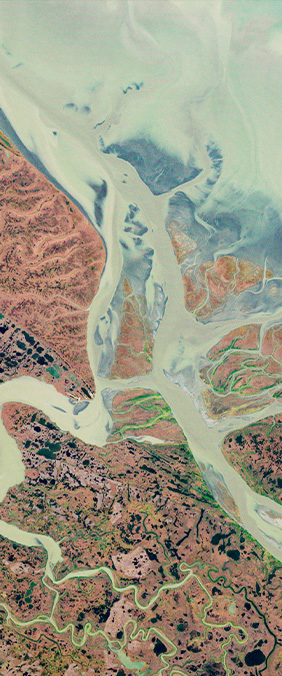
In western Alaska, the Yukon River shatters into hundreds of channels before reaching the Bering Sea — a delta so finely braided that, in winter, frozen tributaries draw the unmistakable bowl of an A across 25,000 km² of tundra. Landsat captured it from 705 km up, where geometry stops being human and starts being elemental.
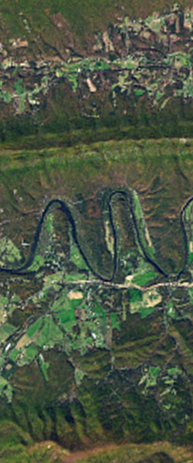
The Shenandoah bends through the Blue Ridge in three near-perfect switchbacks, drawing — from orbit — a lowercase m. The loops were carved over millions of years as the river found the path of least resistance through soft limestone. Geologists call them meander cutoffs. We prefer to call them the Earth's penmanship.
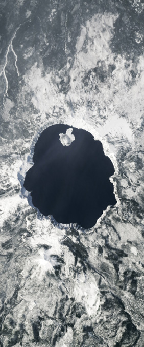
Six miles wide, almost geometrically circular, 594 m deep — Crater Lake fills the caldera left by the violent collapse of Mount Mazama, 7,700 years ago. Landsat sees it as a sapphire eye in the Oregon forest. The water is so pure that sunlight penetrates 30 m before scattering, giving the lake its distinctive deep blue.
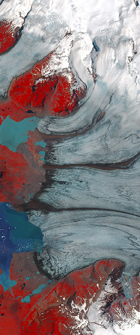
Where Vatnajökull — Europe's largest ice cap — finally meets the North Atlantic, three glacial tongues spread like the prongs of a serif E. Crevasses, moraines, and the milky meltwater of Jökulsárlón lagoon all etch crisp lines into Landsat's frame. Each year the ice retreats another 20 meters, slowly redrawing the letter.
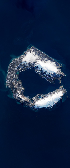
Deception Island is a flooded volcanic caldera at the northern tip of the Antarctic Peninsula. Ships still sail through its narrow opening — Neptune's Bellows — into a near-perfect horseshoe harbor 9 km across, an emphatic C drawn in basalt and sea ice. The volcano last erupted in 1970; the letter has been there longer.
In Abu Dhabi's southern reaches, a dark salt flat cuts perpendicular through pale dunes — a desert T some 50 km wide. The horizontal stroke is a sabkha: a salt-crusted depression where ancient groundwater once rose, evaporated, and left behind crystals that satellites read as graphite-dark stripes against the sand.
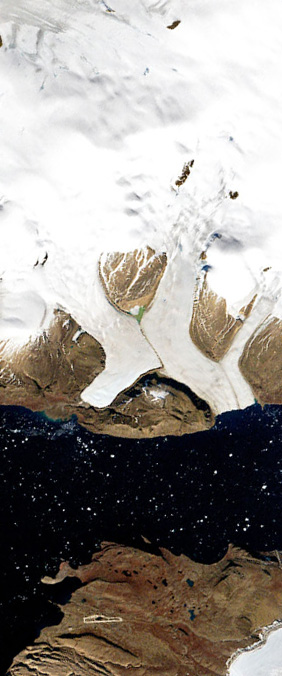
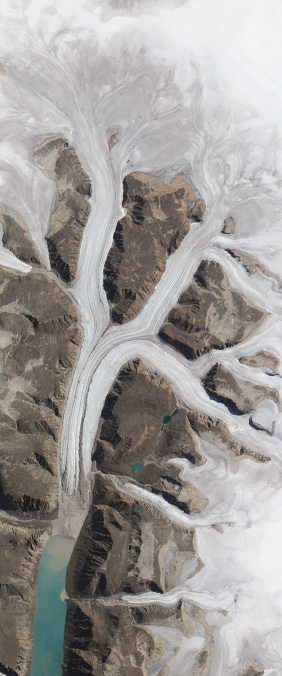
In northwest Greenland, three glaciers converge into Wolstenholme Fjord, their flow lines crossing in a pale, wind-scrubbed X. Landsat has watched this place for fifty years; in that time the ice front has retreated 2.5 km. It is, quietly, a letter erasing itself — an alphabet held hostage by the climate.
Above the Arctic Circle on Bylot Island, glaciers descending from a central icefield meet the rocky coastline at sharp angles, drawing a textbook K in stone and ice. Sirmilik means 'place of glaciers' in Inuktitut. From 705 km up, Landsat confirms what the locals have always known: this place writes its own name.
72°05'01.1" N 76°48'42.9" W
№ 04 — The Landsat program
Fifty years. Nine satellites. One unblinking eye on Earth.
The Landsat program is a joint mission of NASA and the U.S. Geological Survey, and the longest-running record of Earth's surface ever assembled. Since Landsat 1 launched in 1972, the program has imaged the entire planet every 16 days at 30-meter resolution, in nine visible and infrared spectral bands.
Every glacier in retreat, every city in growth, every river that changed course — all of it is in the archive, free to anyone who wants to look. The 71 letterforms in Your Name in Landsat are pulled from that archive. They are, in a quiet way, an alphabet of half a century.
1972Landsat 1
1975Landsat 2
1978Landsat 3
1982Landsat 4
1984Landsat 5
1999Landsat 7
2013Landsat 8
2021Landsat 9
№ 05 — What's in this version
Your Name in Landsat — a reimagined Landsat alphabet.
A
71 hand-curated tiles
Every image is a real piece of Earth, hand-selected by NASA Landsat scientists for the way its geography draws a letter.
B
Deep-link sharing
Every name you create has a unique URL that recreates the exact same letter combination — so friends see precisely what you saw.
C
PNG export, edges trimmed
Download a transparent-background composite at 2× resolution, ready to print as a poster or drop into a card.
D
Open atlas, no signup
Free to use, free to share, free to teach with. Built for curiosity, classrooms, and quiet evenings staring at the planet.
№ 06 — Try a name
A few names to start with.
Click any to render it instantly. Or type your own.
№ 07 — Journal
Stories from the archive.
Deep dives into the geography, science, and art behind Your Name in Landsat.
In western Alaska, the Yukon River shatters into hundreds of channels before reaching the Bering Sea — a delta so finely braided that, in winter, frozen tributaries draw the unmistakable bowl of an A across 25,000 km² of tundra. One of the 71 letterforms in Your Name in Landsat.
The Shenandoah bends through the Blue Ridge in three near-perfect switchbacks, drawing — from orbit — a lowercase m. The loops were carved over millions of years as the river found the path of least resistance through soft limestone. Featured in Your Name in Landsat.
Six miles wide, almost geometrically circular, 594 m deep — Crater Lake fills the caldera left by the violent collapse of Mount Mazama, 7,700 years ago. Landsat sees it as a sapphire eye in the Oregon forest. A perfect O in Your Name in Landsat.
An interactive tool that spells any name using real NASA Landsat satellite imagery. Each letter is matched to a hand-picked piece of Earth whose geography — a glacier, a river bend, a crater — naturally resembles that letter.
Yes. Every tile is an authentic Landsat image taken from 705 km above Earth, sourced from NASA Earth Observatory, NASA Worldview, USGS EarthExplorer, and ESA Sentinel Hub. Hover any letter to see its real-world coordinates.
Yes. Click any letter to open the location in Google Maps. Most are publicly accessible — Crater Lake National Park, Iceland's glacial lagoons, the Florida Keys. A few are not (Antarctica, the Greenland ice sheet, parts of the Arctic).
Yes. Use the download button to export a transparent-background PNG. Print it as a poster, frame it, or share it. The composite is yours to keep, free of charge and free of watermarks.
We use the same hand-curated image library that NASA produced, but rebuilt the experience with editorial typography, longer-form geography essays for each letter, deep-link sharing, and bilingual support. The science is identical; the storytelling is more generous.
No. This is an independent project built in tribute to the original NASA Landsat interactive (created by Ross Walter, Allison Nussbaum, and Ginger Butcher of the Landsat Project Science Support Team). All credit for the imagery and curation belongs to NASA and USGS.
Q is geometrically rare on Earth's surface — there are only so many craters with a tail. We use Lonar Crater (India) and Mount Tambora (Indonesia), both impressive in their own right. Other rare letters: J, X, and Z.
Not yet. The current alphabet covers A–Z only. We're researching whether enough Earth features resemble Chinese radicals (氵, 木, 山) to make a meaningful Chinese-character version. If you have ideas, let us know.
A reimagined version of NASA's Your Name in Landsat interactive. Each letter is matched to a hand-curated Landsat satellite image whose real-world geography resembles that letter.
The Landsat program is a 50+ year joint mission of NASA and the USGS. Imagery is sourced from NASA Earth Observatory, NASA Worldview, USGS EarthExplorer, and ESA Sentinel Hub.
Original concept: Ross Walter, Allison Nussbaum, Ginger Butcher · Landsat PSST. Reinterpretation: a love letter to satellite cartography.