Crater Lake's Perfect O: A Volcanic Alphabet
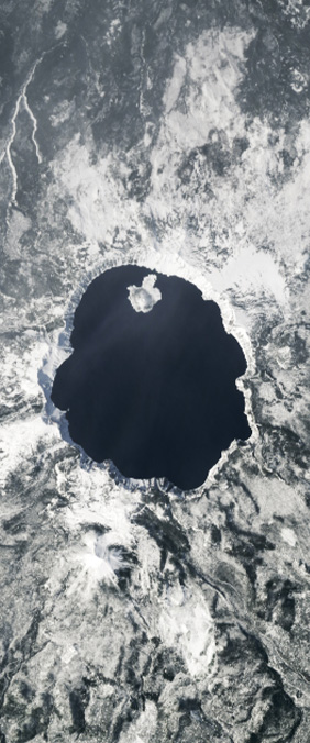
Six miles wide, almost geometrically circular, 594 m deep — Crater Lake fills the caldera left by the violent collapse of Mount Mazama, 7,700 years ago. Landsat sees it as a sapphire eye in the Oregon forest. The water is so pure that sunlight penetrates 30 m before scattering, giving the lake its distinctive deep blue.
The Mazama Eruption
Mount Mazama's eruption was one of the largest in North American history. The volcano ejected an estimated 50 cubic kilometers of material, causing the mountain to collapse into itself. The resulting caldera — 8 by 10 kilometers across — slowly filled with rain and snowmelt over centuries, creating one of the clearest and deepest lakes on Earth.
Because no rivers flow into or out of Crater Lake, its water is extraordinarily pure. Scientists measure its clarity using a Secchi disk, which is visible down to 43 meters — among the deepest readings ever recorded in a natural body of water.
From Space
Landsat's blue and green bands capture the lake's color with remarkable fidelity. The surrounding old-growth forest appears nearly black in certain band combinations, making the O-shaped lake stand out with startling clarity. It's one of the few letterforms in our alphabet that is literally perfect — a circle drawn by catastrophe and filled by patience.