Where a River Writes M: The Shenandoah's Geologic Penmanship
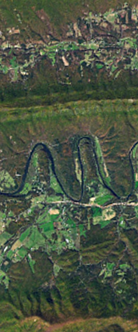
The Shenandoah bends through the Blue Ridge in three near-perfect switchbacks, drawing — from orbit — a lowercase m. The loops were carved over millions of years as the river found the path of least resistance through soft limestone. Geologists call them meander cutoffs. We prefer to call them the Earth's penmanship.
Meander Cutoffs and Oxbow Lakes
As a river meanders, the outer bank erodes while the inner bank deposits sediment. Over time, the bends become tighter until the river cuts through the narrow neck, leaving behind an oxbow lake. The Shenandoah's M-shaped section has survived this process precisely because the limestone bedrock resists rapid erosion.
From Landsat's perspective at 705 km altitude, the distinction between river, floodplain, and forest creates the sharp contrast that makes the letterform legible. The near-infrared band is particularly useful here — healthy vegetation appears bright red, while water absorbs infrared and appears dark.