The Mackenzie Delta's P: The Arctic's Watery Fingerprint
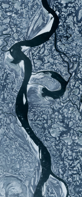
At the northern edge of Canada, where the Mackenzie River finally surrenders to the Arctic Ocean, it spreads into a delta so intricate that Landsat can read it as a letter P. This is the largest river delta in the Arctic, covering roughly 13,000 square kilometers, and it is changing faster than almost any other. The Mackenzie Delta is not just geography — it is a climate sentinel, a transportation corridor, and a homeland for the Gwich'in and Inuvialuit peoples who have lived here for thousands of years.
The River That Defines a Continent
The Mackenzie River is Canada's longest river system, draining an area of 1.8 million square kilometers — nearly one-fifth of the country. It originates in the Great Slave Lake and flows northward for over 1,700 kilometers, gathering water from tributaries that span three mountain ranges and multiple climate zones. By the time it reaches the delta, the river carries not just water but sediment, nutrients, and organic carbon from across a significant portion of North America.
The delta itself is a labyrinth of approximately 25,000 lakes and countless channels. In summer, when the permafrost layer beneath the surface thaws, the ground becomes saturated and the channels overflow, creating a mosaic of standing water, marsh, and braided stream. Landsat's near-infrared band is particularly useful here: water absorbs infrared radiation and appears nearly black, while vegetation reflects it brightly, creating the sharp contrast that makes the P-shaped delta visible from orbit.
Permafrost and a Warming Arctic
The Mackenzie Delta sits on continuous permafrost — ground that has remained frozen for at least two consecutive years, and in some places for tens of thousands of years. As the Arctic warms at roughly twice the rate of the global average, this permafrost is thawing, and the consequences ripple through every aspect of the delta's ecology.
Thawing permafrost causes the ground to subside, creating new ponds and lakes while draining others. It releases methane and carbon dioxide — greenhouse gases that have been locked in frozen organic matter for millennia. It alters drainage patterns, changing which channels carry water and which dry up. And it threatens the infrastructure of the delta's communities, where buildings and roads were constructed on the assumption that the ground beneath them would remain solid.
A Letter from the Edge
The P in our Landsat alphabet is a letter from the edge — the edge of a continent, the edge of the frozen world, the edge of what we used to consider stable. Landsat has photographed it since 1972, and the images tell a story of accelerating change. The letter itself is beautiful: a loop of water and vegetation, a stem of braided channels. But the story it tells is urgent. This is what climate change looks like from space.