Liwa's Green T: An Oasis Written Across the Desert
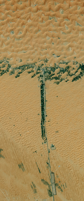
Near 23.175° north and 53.798° east in the emirate of Abu Dhabi, a band of green crosses an arc of farms and settlements. The surrounding dunes are pale tan, so the cultivated land stands out with typographic clarity. In a Landsat 8 image captured on March 9, 2015, the two forms meet as a vast capital T.
A Human-Made Letterform
Many letters in the Landsat alphabet are shaped by rivers, glaciers, volcanoes, or coastlines. Liwa's T is different. NASA Earth Observatory identifies its upright stroke as vegetation planted along highway E45 and its crossbar as the arc-shaped Liwa Oasis. Date palms, farms, roads, and small towns produce the dark green structure that the satellite reads against the desert.
The image has been rotated to make the letter immediately recognizable, but the underlying geography is real. It stretches across the northern margin of the Rub' al Khali, one of the world's great sand deserts. At ground level, the pattern is a network of lived places; from orbit, it becomes a single graphic mark.
Where Green Depends on Water
Liwa has supported settlement for centuries because groundwater made cultivation possible in an otherwise arid region. Date palms became a defining crop, while modern farms added drip irrigation and greenhouses to use water more efficiently. NASA notes that much of the region's supply comes from deep aquifers containing water accumulated under wetter climates thousands of years ago.
That contrast gives the satellite image both its beauty and its tension. The green T is evidence of careful cultivation, but every planted line also represents a demand for scarce water. Landsat's repeated observations help researchers distinguish vegetation from bare sand and follow how irrigated land changes over time.
The Alphabet Between Nature and Culture
Liwa complicates the idea that an Earth alphabet must be purely natural. Its letter is neither an arbitrary drawing nor an untouched landform. It emerges where geology, infrastructure, agriculture, and human history overlap. The dunes provide the page; roads and farms supply the strokes.
Seen this way, the T is more than a visual coincidence. It is a compact portrait of how people inhabit a difficult landscape—organizing movement around a road, growing food around available water, and leaving a pattern large enough to be read from 705 kilometers above Earth.
Sources and Further Reading
NASA Earth Observatory: The Alphabet from Orbit—Letter T
NASA Science: Your Name in Landsat