Holuhraun's Black I: When Iceland Would Not Sleep
Between August 2014 and February 2015, a fissure eruption in Iceland's interior produced the largest lava flow on the island since 1783. The resulting field — dark, rippled, and shaped like the letter I — is visible from orbit as a fresh scar on an already volcanic landscape. The Holuhraun lava field covers 85 square kilometers, and in the years since the eruption ended, it has become one of the most studied young lava surfaces on Earth. Landsat watched it form in near real-time.
The Bárðarbunga System
The eruption originated from the Bárðarbunga volcanic system, a network of fissures and magma chambers located beneath Iceland's Vatnajökull ice cap and extending northeastward into the Holuhraun plain. On August 16, 2014, seismic instruments detected a swarm of earthquakes as magma began to move horizontally through a subsurface dike — a vertical sheet of molten rock forced between existing rock layers.
The dike propagated northeast at speeds of up to five kilometers per day, cutting a path through the crust until it reached the surface on August 29 near the northern edge of the Dyngjujökull glacier. What followed was six months of continuous eruption: lava fountains rising tens of meters, a volcanic plume that occasionally reached the stratosphere, and a river of molten basalt that eventually covered an area larger than Manhattan.
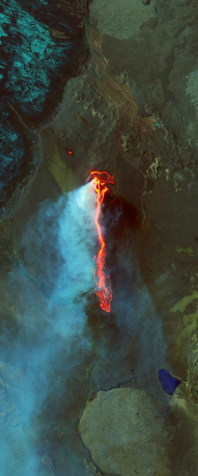
Fire Meets Ice
One of the most dramatic aspects of the Holuhraun eruption was its proximity to ice. The Dyngjujökull glacier sits just south of the eruption site, and for weeks scientists worried that lava might flow beneath the ice, triggering catastrophic floods known in Iceland as jökulhlaups. Such floods have reshaped Iceland's landscape repeatedly over millennia, carving canyons and depositing sediment across vast plains.
Landsat 8, which had launched just two years earlier, captured the eruption with unprecedented clarity. The satellite's thermal infrared bands recorded the lava's surface temperature — often exceeding 1,000 degrees Celsius — while its shortwave infrared bands penetrated the volcanic gas plume to map the advancing lava front. These images were not just scientifically valuable; they were essential for hazard assessment, helping authorities decide when to evacuate nearby areas and close airspace.
A New Letterform
The Holuhraun lava field has cooled and solidified into a landscape so dark and uniform that, from Landsat's altitude, it resolves into a sharp vertical stroke — the letter I. But unlike most letters in our alphabet, this one is brand new. It did not exist before 2014. It is a reminder that the Earth is still writing, still forming its alphabet, and that Landsat is there to read every new character.