The Great Barrier Reef's J: A Living Letter Under Threat
Off the coast of Queensland, Australia, the world's largest coral reef system curves through the Coral Sea in a shape that resembles the letter J. From space, it is a turquoise thread against deep blue. From the water, it is an ecosystem so complex that scientists are still mapping its full biodiversity. The Great Barrier Reef is not just a wonder of the natural world — it is a living structure visible from 705 kilometers above the Earth, and Landsat has been watching it for fifty years.
The Architecture of Coral
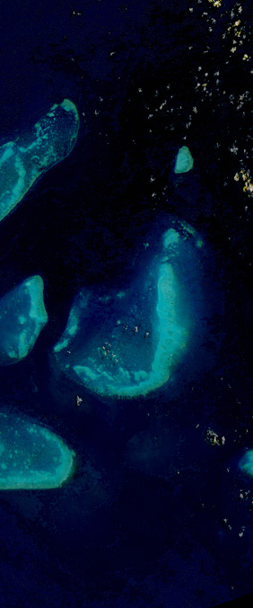
The reef stretches over 2,300 kilometers along Australia's northeastern coast, comprising roughly 3,000 individual reefs and 900 islands. It is the only living structure visible from space. The J-shaped section captured in our Landsat alphabet lies in the northern Whitsunday region, where a cluster of fringing reefs extends seaward in a gentle curve that, from the satellite's perspective, resolves into a lowercase j.
Coral reefs are built by billions of tiny coral polyps — colonial animals related to jellyfish — that secrete calcium carbonate skeletons. Over thousands of years, these skeletons accumulate into the massive limestone platforms that form the reef structure. The vivid colors seen in Landsat imagery come not from the coral itself, which is often brown or pale, but from the symbiotic algae called zooxanthellae that live within the coral tissue and give reefs their characteristic turquoise and green appearance.
Bleaching and Resilience
Since 2016, the Great Barrier Reef has experienced three mass bleaching events — in 2016, 2020, and 2022 — caused by rising sea temperatures. When water becomes too warm, corals expel their zooxanthellae, turning white and starving. If temperatures remain elevated, the corals die. In the 2016 event alone, an estimated 29 percent of the reef's shallow-water corals perished.
Landsat data has become essential for monitoring these changes at scale. The satellite's coastal aerosol band and shortwave infrared bands can distinguish between healthy coral, bleached coral, and dead coral with increasing accuracy. By comparing images across decades, researchers can track the pace of recovery — or decline — across the entire reef system, not just the small patches accessible to divers.
A Letter Worth Saving
The J in our Landsat alphabet is more than a geographic curiosity. It is a 2,300-kilometer argument for the value of long-term Earth observation. Without Landsat's continuous record, we would not know how quickly the reef is changing, where recovery is strongest, and where intervention is most urgently needed. The letter is beautiful. The science it enables is indispensable.