Etosha's I: A Salt Desert Written in White
In northern Namibia, a dried lakebed the size of a small country stretches beneath the sun — blinding white, perfectly flat, and shaped like the letter I. The Etosha Pan is one of the largest salt flats on Earth, covering roughly 4,800 square kilometers, and Landsat has watched it transform with the seasons for half a century. What appears from space as a stark white rectangle is, on the ground, a landscape of such extreme conditions that almost nothing lives on it — and yet everything around it depends on it.
The Lake That Dried
The Etosha Pan is the remnant of a vast paleolake that once covered much of northern Namibia. Fed by ancient rivers during wetter climatic periods, the lake began to dry approximately 16,000 years ago as the regional climate shifted toward aridity. What remains is a shallow depression — rarely more than a few meters deep — with a floor of compacted clay and salt crusts that can extend for tens of kilometers without a single break in flatness.
The pan's surface is not uniform. In the dry season, it is a cracked mosaic of salt polygons, each one a crystalline basin formed by repeated cycles of flooding and evaporation. During the brief wet season, when thin sheets of water collect after rains, the pan becomes a mirror that reflects the sky so perfectly that the horizon disappears. Pilots flying over Etosha during these conditions report vertigo — the ground and sky become indistinguishable.
Life on the Edge
Though the pan itself is almost lifeless, its edges support one of Africa's most remarkable wildlife ecosystems. Elephants, lions, zebras, springbok, and hundreds of bird species gather at the pan's margins and at the scattered waterholes that dot the surrounding savanna. During drought years, the waterholes become the only reliable water sources for hundreds of kilometers, concentrating animals in densities that rival the Serengeti.
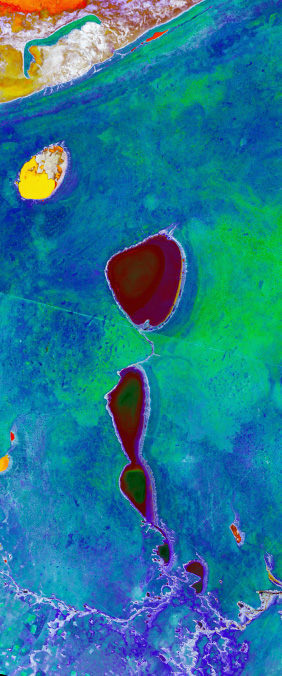
Landsat's shortwave infrared and thermal bands are particularly useful for tracking the pan's seasonal rhythms. The salt crust reflects strongly in the near-infrared, making the pan appear almost luminous in false-color imagery. When water accumulates, the spectral signature changes dramatically, allowing researchers to map the extent of seasonal flooding and correlate it with wildlife migration patterns observed on the ground.
A Letter of Extremes
The I in our Landsat alphabet is a letter of extremes — extreme heat, extreme flatness, extreme whiteness. It is a landscape that has been stripped down to its geological skeleton, a lakebed that outlived the lake. From orbit, it is a simple vertical stroke. From the ground, it is a world.