Deception Island's Horseshoe C: A Volcano That Swallowed the Sea
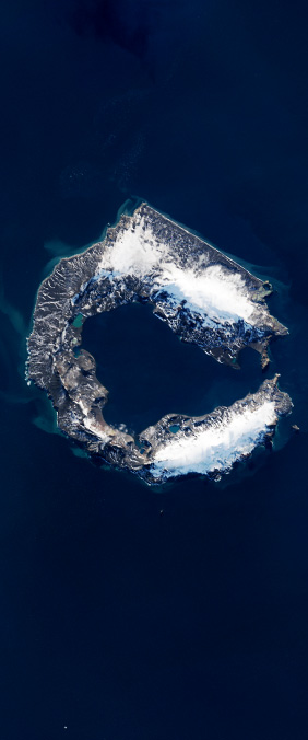
In the South Shetland Islands, just off the Antarctic Peninsula, a flooded volcanic caldera forms a near-perfect horseshoe — the letter C drawn by catastrophe. Deception Island is one of the few places on Earth where you can sail into an active volcano. The caldera walls rise from the sea like a broken ring, enclosing a harbor called Port Foster where whalers once anchored and where scientists now study one of the most geologically dynamic environments on the planet.
The Eruption That Created the C
Deception Island's distinctive shape was born roughly 10,000 years ago when a massive volcanic eruption emptied the magma chamber beneath the mountain. The summit collapsed inward, creating a caldera roughly 15 kilometers across. The sea eventually breached the caldera's northwestern wall — a narrow gap called Neptune's Bellows — flooding the interior and leaving behind the horseshoe outline that Landsat sees from orbit.
The island remains active. Its most recent significant eruption occurred in 1970, when pyroclastic flows and lava destroyed British scientific stations. Smaller seismic events continue regularly, reminding researchers that the magma chamber is still restless. The island sits on the Bransfield Strait, a tectonic rift where the Antarctic Plate and the Shetland Plate are pulling apart, providing a constant supply of heat and magma.
A Harbor Inside a Volcano
Port Foster, the flooded interior of the caldera, is one of the safest natural harbors in Antarctica — paradoxically protected by the very walls of an active volcano. During the early 20th century, Norwegian and British whaling fleets established stations on the island's beaches. The remnants of those operations — rusted boilers, collapsed buildings, and whale bones bleaching on the black volcanic sand — still stand as a stark reminder of humanity's reach into even the most extreme environments.
Today, the island hosts research stations from Argentina and Spain, and it serves as a critical site for studies on Antarctic geology, microbiology, and climate. The geothermal heat beneath the island's beaches is strong enough to melt snow in places, creating patches of bare ground that support unique moss and lichen communities found nowhere else in Antarctica.
From Space, a Letter
Landsat has captured Deception Island dozens of times since 1972, and in most images the C-shaped caldera is unmistakable. The dark volcanic rock contrasts sharply with ice and snow, and the narrow opening to the sea creates a dramatic gap in the horseshoe. It is a letterform written by one of the most violent forces on Earth — a reminder that the alphabet we see from space is not just decorative, but a catalogue of geologic power.