Iceland's Glacial E: A Letter Redrawn by Retreat
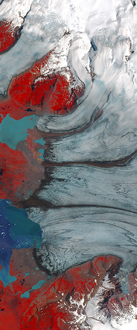
At the southeastern edge of Iceland, crevasses and ice streams flow away from the Vatnajökull ice cap in three strong horizontal strokes. In a Landsat 8 image acquired on September 25, 2015, those lines meet a darker vertical edge and resolve into a capital E. It is one of the clearest frozen letterforms in the Your Name in Landsat collection.
An Outlet of Vatnajökull
Breiðamerkurjökull is an outlet glacier of Vatnajökull, Iceland's largest ice cap. Ice moves from the high interior toward the Atlantic coast, carrying dark bands of rock and sediment along its surface. From orbit, the contrast among snow, exposed ice, moraine, and meltwater makes the glacier's structure unusually legible.
The USGS Landsat record for this area reaches back to 1973. Image after image shows a landscape in motion: the glacier tongue has been in sustained retreat since roughly 1930, while newly exposed ground and water have occupied the space left behind. A single satellite image creates the letter; the archive reveals how that letter changes.
The Lagoon at the End of the Ice
Jökulsárlón began forming around 1935 as Breiðamerkurjökull pulled away from the coast. NASA reports that the lagoon has quadrupled in size since the 1970s and now covers roughly 11 square kilometers. Icebergs calve from the glacier front, drift across the lagoon, and eventually pass through a narrow channel toward the ocean.
This is why the E should not be read as a permanent symbol. Its strokes are flow lines, fractures, and sediment bands inside moving ice. As the terminus retreats and the lagoon grows, the proportions of the letter are redrawn. Landsat does more than preserve a striking shape; it records the process that is transforming it.
Reading Change as a Letter
Satellite imagery often makes environmental change easier to grasp by turning decades of measurements into visible form. Here, the alphabet provides an unexpected point of entry. First we notice an E. Then we notice the widening water, the shifting ice front, and the dark terrain emerging from beneath the glacier. The letter invites us to look; the Landsat record asks us to keep looking.
Sources and Further Reading
NASA Earth Observatory: Iceland's Glacial Lagoon
USGS Earthshots: Breiðamerkurjökull Glacier, Iceland